The land was gifted to the British Crown by Māori in 1887, and seven years later became New Zealand’s first national park. Today it draws around a million visitors a year, lured by world-class hiking and skiing in one of the country’s most accessible wilderness areas.
The park anchors the southern end of the Taupō Volcanic Zone, itself part of the Pacific Ring of Fire – the vast chain of volcanic activity that arcs from the tip of South America up to North America, across the Bering Strait, through Japan, and down to Aotearoa. The first lava flows here appeared some 270,000 years ago, and eruptions continued regularly for the next 200,000 years.
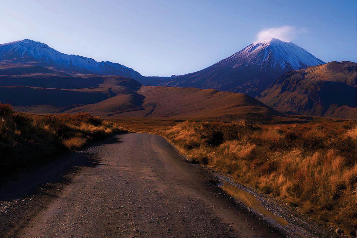
Three great peaks preside over this smouldering landscape: Tongariro, Ruapehu, and Ngāuruhoe – the latter immortalised as Mount Doom in the Lord of the Rings films. Ngāti Tūwharetoa tell of a time when the North Island’s mountains stood clustered together, locked in rivalry for the affections of Pihanga, a peak rising between Lakes Rotoaira and Taupō. Tongariro, the Warrior Mountain, prevailed, sending the others into retreat. Among the vanquished was Mount Taranaki, exiled to the west coast, his flight carving out the course of the Whanganui River. These peaks are not merely mountains but serve as guardians of the land.
Tongariro and Ngāuruhoe are best experienced on the Tongariro Alpine Crossing, a full-day hike widely considered as among the best day walks on Earth. Ruapehu rewards the more committed walker with a crater lake summit that takes at least five hours return, while in winter its slopes become the North Island’s finest ski area.

Tongariro Alpine Crossing
The 20.4km Tongariro Alpine Crossing is a constantly shifting procession of volcanic craters, luminous lakes, and sweeping alpine views. The trek can be walked in either direction, but most hikers start at the Mangatepopo car park and finish at Ketetahi, off State Highway 46. Allow seven to eight hours for the crossing, which begins at 1,120m and follows a well-marked, well-maintained trail throughout. There are steep sections in both directions, but anyone with a reasonable level of fitness should find it manageable — and there’s no shortage of places to stop, catch your breath, and take in the scenery.
The first hour is relatively gentle, tracing the Mangatepopo Stream past the fizzing Soda Springs before the track climbs steeply into the valley and across the saddle between Tongariro and Ngāuruhoe. Beyond the saddle, the trail passes through Tongariro’s rust-coloured South Crater before rising again to Red Crater, the highest point on the crossing at 1,886m.
After a short, steep descent, the trail levels out toward the mesmerising Emerald Lakes, pooled in vivid turquoise against the dark volcanic earth. Continuing past Blue Lake and onto Tongariro’s northern flank, the path becomes well-formed once more, zigzagging downhill through open tussock before ducking into the welcome shade of native bush.

Mount Ruapehu
At 2,797m, Ruapehu is New Zealand’s tallest volcano and the highest point on the North Island, its broad mass giving rise to several smaller subsidiary peaks. The mountain is a landscape unto itself, cloaked in steaming fumaroles, mineral springs, lava fields, volcanic desert, and glacial valleys, and home to the only glaciers on North Island.
In winter, Ruapehu transforms into the North Island’s premier ski destination, with vertical descents and terrain suited to every level of skier. The season typically runs from late June through mid-October, occasionally stretching into November when conditions allow.

Whakapapa
Built in the 1920s to serve skiers and outdoor enthusiasts, Whakapapa Village retains that purpose today. Sitting at the foot of Ruapehu, it’s the only permanent settlement within Tongariro National Park and the launching point for many of its best hikes.
Spreading across Ruapehu’s northwest slopes, Whakapapa is New Zealand’s largest ski area, covering 550ha of varied terrain. Happy Valley provides gentle, confidence-building slopes for beginners, while steep chutes, powder gullies, and backcountry trails keep advanced skiers well occupied. On a clear day, the runs are carved with Ngāuruhoe’s snow-capped cone – Mount Doom itself – looming on the horizon.
Tūroa
Spread across Ruapehu’s southwest slopes, Tūroa offers the longest vertical descent of any ski area in New Zealand – 720m from top to bottom. Its signature lift, the High Noon Express chairlift, carries riders to 2,300m, the highest lifted point in the country. For experienced skiers and snowboarders, the mountain serves up an impressive variety of terrain, including natural half-pipes and chutes. Beginners and intermediates are well looked after in the Alpine Meadow area, where wide, sweeping runs keep things fun without being overwhelming.
Tukino
Tucked away on the eastern slopes of Ruapehu, Tūkino is a club-operated ski field with a character all its own. Sheltered from the prevailing westerly winds, its 170ha and 300m-plus of vertical drop are free of the crowds that descend on larger resorts. Access is off the Desert Road between Waiouru and Turangi, and a 4WD is required to get there. Open to the public and visitors alike, Tūkino is a place where all are welcome – whether you’re carving turns, learning the ropes, or simply playing in the snow. When it’s time to warm up, the Tūkino Café and its log fire are waiting.
Waimarino/National Park Village
Sitting at 825m, Waimarino/National Park Village holds the distinction of being Aotearoa New Zealand’s highest township – and the views of the surrounding volcanic peaks more than justify the altitude.
Tūrangi
In a region already renowned for its trout fishing, Tūrangi stands out as the undisputed angling capital. The relaxed town at the southern tip of Lake Taupō was purpose-built in the 1960s to house workers and families of the Tongariro hydroelectric power station, and today it serves as a northern gateway to Tongariro National Park. The Tongariro River, is a magnet for rafters and cyclists, while nearby Mount Pihanga and the secluded Lake Rotopounamu reward those after a pleasant half-day walk. Nearby Braxmere Lodge is a gem.


Ohakune
Ohakune is the southern gateway to Tongariro National Park and easily its most charming. In winter it hums with energy, its chalets and bars filling with skiers using it as a base for Tūroa up the mountain. Come summer, the town shifts gears into a relaxed hub for hikers and cyclists exploring the park. Keep an eye out for the oversized carrot roadside on SH 49 – a cheerful nod to the region’s farming roots.

Taupō
Lake Taupō occupies an ancient volcanic caldera with its waters stretching across an area comparable to Singapore. The caldera formed some 27,000 years ago, but it was dramatically reshaped by an eruption in AD 186 so violent that both Roman and Chinese observers recorded strange colorations in the sky. Today, the lake it left behind is the largest freshwater body in Australasia, giving rise to several rivers – chief among them the Waikato, New Zealand’s longest and most powerful.
A short distance north of Taupō town, which huddles in the lake’s northeast corner, the Waikato thunders through a narrow gorge to become Huka Falls, one of the most visited natural spectacles in the country.
Lake Taupō occupies an ancient volcanic caldera with its waters stretching across an area comparable to Singapore.
Among Taupō’s most compelling attractions are the Māori Rock Carvings at Mine Bay, about 11km southwest of town. Chiseled into a 14m cliff face, the carvings pay tribute to the legendary navigator Ngatoro-i-rangi, believed to be among the first people to settle these sacred lands. Reachable only by boat, they offer a fine reason to get out onto the lake itself – with the peaks of Tongariro National Park rising dramatically over the southern shore. Taupō sits roughly an hour from the park, making it a convenient base for exploring it.
Closer to town, the geothermal park Craters of the Moon delivers an otherworldly landscape of steaming fumaroles and bubbling vents. For those after a rush, the area delivers on multiple fronts: skydiving, jet boating, and a couple of Great Rides all feature on the menu. Fly fishing is another drawcard – the lake and its surrounding rivers are widely regarded as some of the finest trout fishing waters in the world.